Welcome to the arctic monitoring web-site
The Danish Arctic research institutions present updated knowledge on the condition of two major components of the Arctic: The Greenland Ice Sheet and the sea ice
Data Rescue: Greenland Surface Mass Budget Database
From PROMICE Newsletter No. 7 2014
By William Colgan, post doc, GEUS, Horst Machguth, post doc, DTU, Andreas P. Ahlstrøm, researcher, GEUS and Signe B. Andersen, Senior researcher, GEUS
Extensive work rescuing old surface mass balance data is nearing completion and resulting in a new unique data base with measurements from the Greenland ice sheet and peripheral glaciers.
Surface mass budget, the net gain or loss of ice at a location, is an important indicator of ice sheet health. Two thirds of the Greenland ice sheet's current mass loss stems from its surface mass budget with iceberg production accounting for the remaining mass loss. The focus of PROMICE is maintaining a network of automated climate stations in the ice sheet melt area to observe surface mass budget. This network of climate stations is now observing surface mass budgets in eight regions of the ice sheet. The systematic collection of such observations is vital for the calibration and evaluation of regional climate models that simulate surface mass budget, and its change through time, across all of Greenland.
The most comprehensive surface mass budget model inter-comparison to date revealed a dramatic asymmetry in the calibration and evaluation data available in the ice sheet accumulation and melt areas1. Ice cores provide continuous surface mass budget records, over 3000 observation years across 100 sites were available in the accumulation area. By contrast, due to the necessity of repeated visits to measure annual melt, only 100 measurements from one single site were available in the melt area. Naturally, far more observations have been collected in the melt area throughout the history of Greenland glaciology research. A secondary focus of PROMICE has therefore been assembling historical surface mass budget observations from the ice sheet melt area and surrounding local glaciers into a systematic database.
With valuable surface mass budget observations fragmented across studies, most of which are pre-digital or unpublished, or both, these historical data were effectively inaccessible to the global research community. Over the past five years, PROMICE has been digitizing field reports, reconstructing geographic site coordinates, and assessing data quality levels to assemble a database. Institutional knowledge, in the form of long-time GEUS glaciologists Anker Weidick and Henrik Højmark Thomsen, was crucial for knowing "where" and "when" to look for observations, and “how” to interpret and assemble various pieces of information. In collaboration with many partners, both within Denmark and internationally, the PROMICE team is excited to see this data rescue project nearing completion. The database and source documents are the subject of an upcoming scientific publication, and will become openly accessible via the PROMICE website in 2015.
With more than 2400 observations across 36 sites, the new database represents an order-of-magnitude improvement in the melt area and local glacier surface mass budget observations available to the global research community.
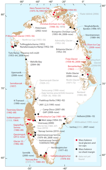
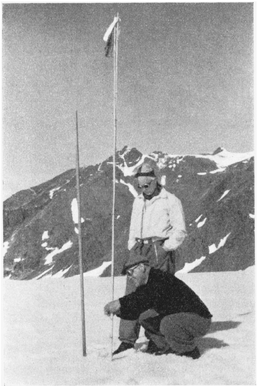
The earliest surface mass budget observations date to a 1938 expedition to Freja Glacier, Northeast Greenland. Approximately 50 % of the observations have not been published before. Only 13 % of the data already existed in tabulated form, including coordinates. Approximately 60 % of the observations originate from GEUS field expeditions (previously by the Greenland Geological Survey, GGU). As data from several expeditions and campaigns have not yet been located, a possibility still exists to further enlarge the number of available observations. Overall, however, this very comprehensive database addresses a pressing community need for data assimilation and provides a powerful tool for understanding the response in Greenland glacier and ice sheet melt to climate over the past century.
 |
PROMICE is financed by the Ministry of Climate, Energy and Building through the climate support programme DANCEA (Danish Cooperation for Environment in the Arctic), which is managed by the Danish Energy Agency.
- The purpose of PROMICE is to monitor the mass loss of the Greenland ice sheet, both the melting on the surface and the volume of icebergs discharged into the sea
- PROMICE is headed in Denmark by GEUS in cooperation with DTU Space and Asiaq in Greenland. Furthermore the programme collaborates with the Danish Meteorological Institute and foreign universities and authorities.
- Read more about PROMICE on promice.org, where you can find photos and videos, get direct access to measuring data from the ice sheet and the PROMICE outreach material. On the website you can also subscribe to our newsletter.
- Information can also be found on porlarportal.org a new website where Danish research institutions display the results of their monitoring of the Greenland ice sheet and the sea ice in the Arctic.