
Welcome to the arctic monitoring web-site
The Danish Arctic research institutions present updated knowledge on the condition of two major components of the Arctic: The Greenland Ice Sheet and the sea ice
Bringing HARMONIE to the Greenland ice sheet
10 July 2017
An interruption in normal Polar Portal service this week has brought unexpected benefits for DMI’s daily surface mass balance data from Greenland… upgrading to the cutting edge HARMONIE-AROME modelling system.
Regular users noticed an interruption in the daily updates to the Greenland surface mass balance on the Polar Portal and on DMI’s homepages. With an unusually snowy winter and a forecast of snow and cold weather over the ice sheet, the scientists were also naturally keen to get the monitoring system back as soon as possible. “We were actually surprised how many people got in touch to ask about the daily SMB data – it’s nice to know so many people are interested in what’s happening in Greenland” said Ruth Mottram a climate scientist and glaciologist at DMI who works with Greenland SMB data.
The stoppage was caused by technical problems with the observational data from Arctic Canada that are assimilated into the HIRLAM K05 model that DMI uses to drive the surface mass balance model. Solving these problems is a complex task and with a skeleton staff, due partly to the July holiday period, it was looking like the SMB data would not be back online until much later.
“July is the month which sees the most melt in Greenland, if we were to miss the summer period it would be really difficult to say anything about the surface mass balance over the whole year so we were really keen to get the model back online as soon as possible” said Ruth Mottram
Fortunately, there was a back-up plan. The HIRLAM K05 weather model is being phased out by DMI to be replaced by HARMONIE-AROME, a state-of-the-art new model with advanced numerical solutions for atmospheric physics, developed by the ALADIN and HIRLAM-C group – a weather modelling consortia. What if, the scientists wondered, we could run the surface mass balance model with output from HARMONIE-AROME instead of HIRLAM?
“The weather forecasters have noted significant improvements in the forecasts after the HARMONIE-AROME model was implemented for southern Greenland” said Kristian Pagh Nielsen one of the developers of the model at DMI. “HARMONIE-AROME has so far only been used for smaller areas. Now we have set up a new model simulation that covers the whole of Greenland at an unprecedented 2.5 km resolution from the 2016/2017 winter.”
The experimental HARMONIE-AROME model set-up has been running in the background since then, allowing the model developers, forecasters and climate scientists at DMI to compare the performance of HARMONIE-AROME with the old HIRLAM K05 model and with the observations made in Greenland, before the planned switch-over in September 2017. “We knew that we would at some point start to run the surface mass balance model with the new HARMONIE-AROME output so we have been saving the fields we need since February” said Kristian Pagh. The problem with Greenland, according to Xiaohua Yang, lead developer of HARMONIE-AROME at DMI is that there aren’t enough observations to check how well this model, or any other, works in forecasting. “We have done as much analysis as possible and we’re reasonably confident that HARMONIE-AROME does a better job than HIRLAM K05 in forecasting precipitation, winds and temperature, but especially somewhere like Greenland we have to constantly verify our results and ideally we’d like a full year to do that.”
After some hard work over the weekend, the surface mass balance model is now back online and being forced, from the 1st July, with the HARMONIE-AROME model. The SMB is being produced using the exact same model as prior to 1st July, taking into account the same snow pack process, as described previously. The only difference is the atmospheric model has changed. As the old model ran at 5 km resolution, the input fields have also been reduced from the native 2.5 km resolution of HARMONIE-AROME to the same 5 km resolution. This is to ensure that the modelled SMB is comparable to that earlier in the year, but also with the background climatology, produced using yet another model, the HIRHAM5 regional climate model – a close relative of the old HIRLAM K05 weather model.
Peter Langen, developer in chief of the SMB model cautions that “the model is still experimental. Although for the overlapping period we see quite similar results, there are some small differences which might end up being important. For now though, this is a great opportunity for us to really see how well HARMONIE-AROME performs over the Greenland ice sheet and to compare it later on with the old HIRLAM model and with the observations that GEUS have on the ice sheet in the PROMICE network”.
Martin Stendel, Polar Portal leader, agrees. “This year has been extremely unusual, with a snowy winter and then a cool period at the start of this month. It’s extremely important we get the surface mass balance right.”
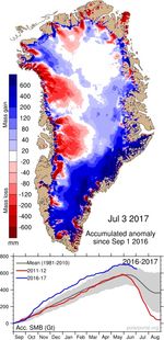
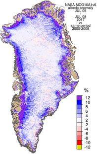
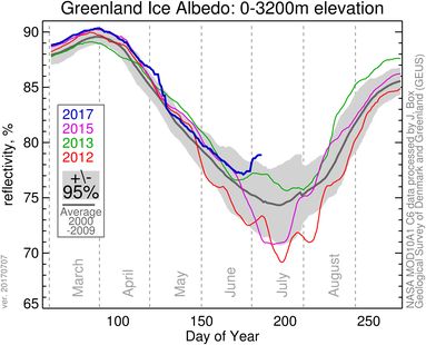
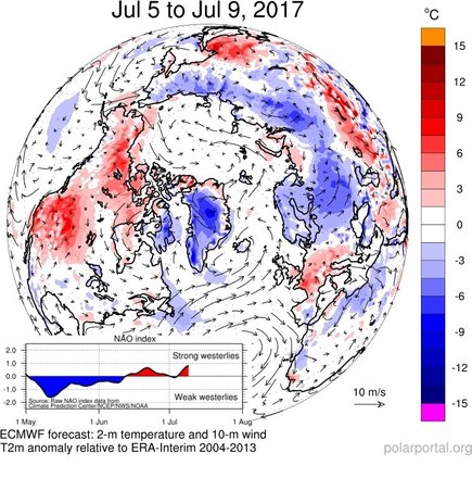
The period from the 27th June to the 5th July saw days with close to zero or even slightly positive SMB (a net gain in mass) as well as a record low temperature recorded at the DMI weather station at Summit -33.0 °C. This weather along with the snowfall in early June, and following from the heavy snow in the Autumn, has led to a relatively high surface mass balance for the time of year and an unusually bright and reflective ice sheet, as shown in the albedo anomaly map on the Polar Portal (and below). Professor Jason Box of GEUS explains “when we see cold snowy conditions like this in the summer time it brings melt to a halt. The fresh snow is bright and reflects sunlight whereas in normal years dark bare glacier ice is usually exposed at this time of year and so melt rates are strong. This is why we track the albedo through the year to see how much melt we can expect”.
 |
 |
 |
* (link in figure to the left: The snowy winter was responsible for the higher than usual values in the south east of Greenland.
So far this summer there has been less melt than usual. As DMI weather forecaster Jesper Rosberg explains, “we have seen a persistent positive North Atlantic Oscillation this summer and the jet stream has been very far south of Greenland with very cold air over the ice sheet, so the precipitation falling this summer has mostly been snow, rather rain. ”
 |
The cold and snowy conditions have been hindering scientific fieldwork this summer. But there are still several weeks of the ablation season left and the weather for the rest of July and August will determine the surface mass balance of Greenland this year. As far as DMI scientists know this is the first time that the SMB of the Greenland ice sheet has been calculated with such a sophisticated model in near real-time and it’s all the more interesting since we have snowfall interfering with melt.
 |
The HARMONIE-AROME model set-up is described in full in this open access paper by Bengtsson et al., 2017.
Polar Portal is a collaboration between DMI, GEUS, DTU-Space and DTU-Byg with funding from the Danish Energy Agency (Energistyrelsen).
Polar Portal is also on Twitter: @PolarPortal and Facebook: https://www.facebook.com/PolarPortal/.
