

Welcome to the arctic monitoring web-site
The Danish Arctic research institutions present updated knowledge on the condition of two major components of the Arctic: The Greenland Ice Sheet and the sea ice
Late Arctic sea ice minimum 2018
This year, the Arctic sea ice extent reached its annual minimum late in the season: On September 19th a first minimum was reached, and it was followed by a second minimum on September 23rd. Tied only with 1997, this is the latest day of occurrence of the summer minimum in sea ice extent since start of the satellite record. The current annual minimum is the 6th lowest sea ice extent in the record, tied with 2008 and 2010. This year will, however, probably be remembered primarily for the unusual opening in the otherwise very robust sea ice areas north of Greenland.
Compared to the last 40 years, for which we have satellite observations of Arctic sea ice, the minimum sea ice extent did not set a new record this year. While being about 2 mill. km² below the 1981-2000 average, it is still about 1.2 mill. km² above the 2012 minimum record. The annual minimum is the 6th lowest minimum in the 40 year record, and the september mean sea-ice extent was the 9th lowest recorded by satellite measurements since 1979 (http://ocean.dmi.dk/arctic/sie_monthmean.uk.php). During the first four months of 2018 the sea ice extent was record low for each of these months. September 23rd marked the end of the melt season and the beginning of the ice growth season. Over the next six months, the sea ice will expand by approximately 10 mill. km². The sun over the North Pole has set on September 20 at equinox and will not rise before March 2019, and temperatures are well below freezing now.
Three things in particular influence the sea ice extent at the end of the melt season: 1) the sea ice thickness and robustness at the beginning of the melt season, 2) when the melt season starts, and 3) weather during the melt season.
DMI’s sea-ice model simulations show that the sea ice thickness at the beginning of the melt season this year was slightly thicker than last year. Compared to last year, this gave the Arctic sea ice a better chance of surviving the 2018 summer melt season.
Timing of the onset of melt is important for the sea-ice energy balance and the sea-ice extent. Solar radiation is at a maximum in the Arctic Ocean before mid-summer because of the midnight sun, the solar angle, and because it is less cloudy at this time of the year compared to later during the melt season. As a matter of fact, the top of the atmosphere above the North pole is the place on Earth receiving most solar radiation during midsummer. When the snow on the sea ice starts melting, it changes its ability to reflect sunlight. Melting sea ice absorbs more sunlight than cold and freezing sea ice. Therefore, the combination of high temperatures and clear skies in June, when the central Arctic starts melting, can change the sea-ice energy balance so much that an early melt in June is correlated with a low sea ice extent in September. This year, however, the melt started near the normal date for melt in June, and it was therefore not an indicator for more or less ice in September.
During the 2018 melt season, the Arctic weather differed between the eastern and western Arctic: North of Canada, the weather was colder than usual, while it was warmer than usual north of Siberia. This had a direct influence on sea-ice conditions in these areas, and hence for navigability along the northwest and northeast passages: The north-east passage was open, while the northwest passage was clogged with ice along some sections.
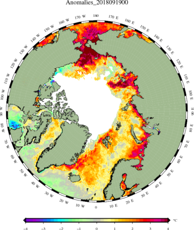
The sea-ice cover, or rather the absence of sea ice, has a direct influence on the heating of surface waters during summer. Along the Siberian coast, in the Bering Strait and in the Greenland Sea there are currently large areas where the surface water temperature is 2⁰C, 3⁰C, and even 4⁰C above normal. The high water temperatures will delay the freeze-up during this autumn.
The figure shows the sea surface temperature anomaly in the Arctic on Sep. 19, 2018. Warm (red) colors shows areas where the surface temperature is warmer than normal, and cold (blue) colors shows areas where the surface temperature is colder than normal. The map is based on satellite data.
The Arctic sea-ice season 2018 will be remembered mostly for two very unusual events of openings of the sea-ice cover north of Greenland. The perennial sea ice north of Greenland is among the thickest and most robust sea ice in the Arctic,. However, in late February 2018 persistent strong and warm winds blew the sea ice away from the coast and created an opening several hundred kilometers long and in some places 100 km wide. Subsequently, the temperature returned to more normal winter temperatures for the area (-30⁰C to -20⁰C), and the opening was covered with ice that froze relatively late during the winter. The sea ice in this area north of Greenland normally survives the summer melt season. However, the late re-freezing resulted in a relatively thin sea-ice cover, which melted away again in August.
The openings north of Greenland were relatively short-lived events, which did not affect the sea-ice extent significantly. However, if such breakup of old robust multi-year ice continues, it may threaten its stability. If the multi-year ice breaks up and drifts south, there is a high risk of having ice free summers in the Arctic Ocean. This would have severe consequences for the global climate and for the wildlife living on, under and around the sea ice.
Rasmus Tonboe, Mai Winstrup, Gorm Dybkjær, Matilde Kreiner
